Thurgau at a glance
Key figures on the Canton of Thurgau
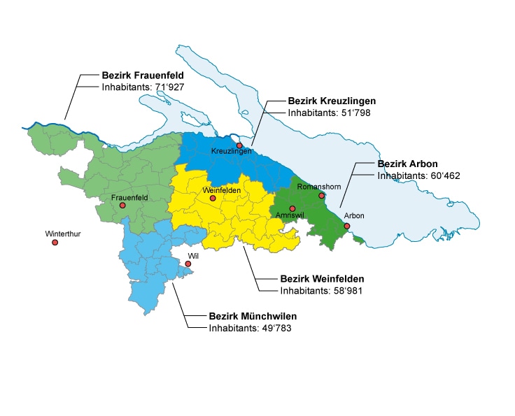
| Districts ("Bezirke") | 5 | |
| Political Municipalities | 80 | |
| Area | 991 km2 | |
| Table: Political Municipalities of the Canton of Thurgau Explore — Open Data Kanton Thurgau (tg.ch) |
||
| Geography | ||
| Northernmost point | In the middle of Rhein River ("Schaarenwiese", Schlatt) | |
| Southernmost point | Point of intersection of Canton Thurgau, St. Gallen and Zurich (Fischingen) | |
| Easternmost point | Confluence of Goldach River into Lake Constance (Horn) | |
| Westernmost point | Mountain Kohlfirst (Schlatt) | |
| Highest point | Hohgrat (Fischingen), 991 m.a.s.l. | |
| Lowest point | Effluent of Thur River out of the Canton (Neunforn), 370 m.a.s.l. | |
| Distances | ||
| Maximum distance north-south | 35 km | |
| Maximum distance east-west | 61 km | |
| Population | ||
| Total population 2023 | 292'951 | |
| Percentage of foreigners 2023 | 26,5 % | |
| Population density 2023 | 3,4 inhabitants per hectare land area | |
Economy |
||
| Persons employed 2022 (in full-time equivalents) | 112'282 | |
| Percentage of persons employed by sector: | ||
| Agriculture | 5,4 % | |
| Industry | 34,0 % | |
| Services | 60,6 % | |
| Unemployed persons 2023 | 2'843 | |
| Unemployment rate 2023 | 1,9 % | |
| Gross Domestic Product, 2021 (provisional) | 19'274 million Swiss francs | |
| Gross Domestic Product per capita, 2021 (provisional) | 67'764 Swiss francs | |
| Politics | ||
| Party strength Grand council election, 2024 | ||
| SVP | 32,5 % | |
| Die Mitte | 15,2 % | |
| FDP | 12,7 % | |
| SP | 12,1 % | |
| GRÜNE | 8,8 % | |
| GLP | 6,4 % | |
| EVP | 4,9 % | |
| EDU | 4,7 % | |
| AUFTG | 2,1 % | |
| Others | 0,5 % | |
| Party strength National Council election 2023 | ||
| SVP | 40,3 % | |
| Die Mitte | 15,3 % | |
| FDP | 10,7 % | |
| SP | 10,2 % | |
| GRÜNE | 8,5 % | |
| GLP | 6,6 % | |
| EDU | 2,8 % | |
| EVP | 2,4 % | |
| Others | 3,0 % |
Thurgau in Zahlen 2024 (in German)
Thurgau in Focus - Statistical Yearbook 2023 (in German)
Sustainable development in the canton of Thurgau: sustainability indicators MoniThur (in German)
Sources: Geography, Distances: Amt für Geoinformation Kanton Thurgau; Population: Dienststelle für Statistik Kanton Thurgau, Bundesamt für Statistik, Arealstatistik; Economy: Bundesamt für Statistik, STATENT 2021 (Employed persons), SECO (unemployed persons), Bundesamt für Statistik (Gross Domestic Product); Politics: Staatskanzlei Kanton Thurgau